


Philip's essential road atlas Britain and Ireland 2015
Title
Philip's essential road atlas Britain and Ireland 2015
Philip's essential road atlas Britain and Ireland 2015
format
Paperback / softback
Paperback / softback
Publisher
Philip's
Philip's
Language
English
English
UK Publication Date
20150706
20150706
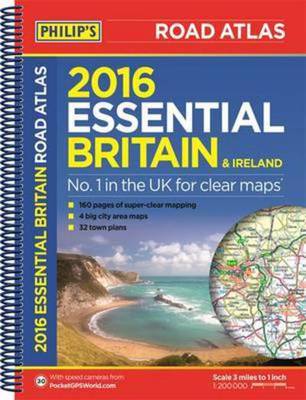
Philip's Essential Road Atlas Britain and Ireland 2016 contains 160 pages of road maps covering Britain at 3 miles to 1 inch, with the Western Isles, Orkney and Shetland at smaller scales. The maps clearly mark service areas, roundabouts and multi-level junctions, and in rural areas distinguish between roads over and under 4 metres wide - a boon for drivers of wide vehicles.
The atlas also includes 10 pages of route-planning maps, a distance table, 4 large-scale city approach maps with named arterial roads, and 32 extra-detailed town and city plans.
We are Rated Excellent on Trustpilot
Here's what you say about us...
We are Rated Excellent on Trustpilot
Here's what you say about us...
Type
BOOK
Keyword Index
Roads - Great Britain - Maps.|Great Britain - Maps.
Country of Publication
England
Number of Pages
1 atlas (224 )